-
相關路線
Outdoor activities carry inherent risks. Please choose routes within your ability, do your homework, prepare adequate gear, download offline track maps for reference, make a plan, set a turnaround time, and take responsibility for your own safety. Also, please pack out all the trash you bring into the mountains.
Leave No Trace in the wilderness.
-

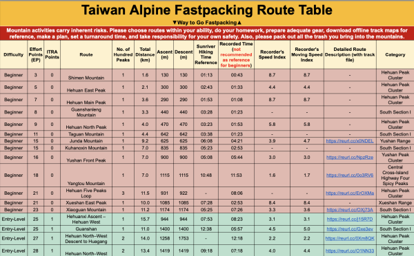
Taiwan Alpine Fastpacking Route Table
The table includes: difficulty, Effort Points (EP), route name, number of Hundred Peaks, total distance (km), ascent (m), descent (m), Sunriver time, recorded time, speed index (EP/hr), moving speed index, detailed route description (with track files), and category.
- Link: https://reurl.cc/kpqKaq
How to Choose a Route
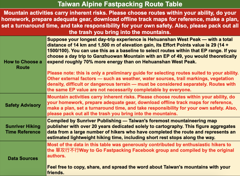
Suppose your longest day-trip experience is Hehuanshan West Peak — with a total distance of 14 km and 1,500 m of elevation gain, its Effort Points value is 29 (14 + 1500/100). You can use this as a baseline to select routes within that EP range. If you choose a day trip to Ganzhuowan Mountain with an EP of 49, you would theoretically expend roughly 70% more energy than on Hehuanshan West Peak. Please note: this is only a preliminary guide for selecting routes suited to your ability. Other external factors — such as weather, water sources, trail markings, vegetation density, difficult or dangerous terrain — must be considered separately. Routes with the same EP value are not necessarily completable by everyone.
Safety Advisory
Outdoor activities carry inherent risks. Please choose routes within your ability, do your homework, prepare adequate gear, make a plan, set a turnaround time, and take responsibility for your own safety.
Sunriver Hiking Time Reference
Compiled by Sunriver Publishing — Taiwan's foremost mountaineering map publisher with over 20 years dedicated solely to cartography. This figure aggregates data from a large number of hikers who have completed the route and represents an estimated lightweight hiking time, including short rest stops along the way.
Data Sources
Most of the data in this table was generously contributed by enthusiastic hikers to the 單攻行不行Way to Go Fastpacking Facebook group and compiled by the original authors.
Feel free to copy, share, and spread the word about Taiwan's mountains with your friends.
Route Grade Definitions
🟢 Beginner Routes
- Completable within 12 hours, with roughly the same outbound and return path — no shuttle required for safety or retreat
- Total distance does not exceed half-marathon distance (21.0975 km)
- EP ≤ 25 (distance in km + ascent in m ÷ 100)
- Total ascent does not exceed 2,500 m
- Accessible via a legal one-day national park permit
🔵 Entry-Level Routes
- Completable within 12 hours, with roughly the same outbound and return path — no shuttle required
- Total distance does not exceed half-marathon distance (21.0975 km)
- EP ≤ 50
- Total ascent does not exceed 2,500 m
- Accessible via a legal one-day national park permit
🟡 Intermediate Routes
- Completable within 18 hours
- Total distance exceeds half-marathon distance (21.0975 km)
- EP ≤ 80
- Total ascent exceeds 2,500 m
- Accessible via a legal one-day national park permit
🟠 Advanced Routes
- Completable within 24 hours, with roughly the same outbound and return path — no shuttle required
- Total distance exceeds full marathon distance (42.195 km)
- EP ≤ 115
- Total ascent exceeds 4,000 m
- Accessible via a legal one-day national park permit
🔴 Legendary Routes
Beyond all four dimensions — transcendent.
Technical Glossary
Effort Points (EP)
Adopted from the ITRA (International Trail Running Association) method for rating trail difficulty: EP = distance (km) + ascent (m) ÷ 100. The logic is straightforward — hiking 1 km on flat terrain requires roughly the same energy as climbing 100 m vertically. However, mountain routes lack the grooming of organized race courses; difficult terrain such as arrow bamboo thickets or landslide zones requires additional consideration.
Speed Index (EP/hr)
Derived from the above: EP ÷ time (hours). This metric was conceived by Hong Kong's renowned trail runner Wong Ho-chung (7th place at 2019 UTMB). It reflects both route character and individual fitness. For the same route, a higher number means a stronger athlete; for the same athlete on different routes, a higher number means a more runnable (easier to move through) route.
Moving Speed Index
Speed index calculated with rest time excluded.
ITRA Points
| EP | ITRA Points |
|---|---|
| < 25 | 0 |
| < 45 | 1 |
| < 75 | 2 |
| < 115 | 3 |
| < 155 | 4 |
| < 210 | 5 |
| ≥ 210 | 6 |
FKTFastest Known Time — the fastest recorded completion time for a specific route.
Feel free to copy, share, and spread the word about Taiwan's mountains with your friends.
A friendly reminder: safety comes first in the mountains. No matter how high or how hard the climb, the true expert is the one who makes it back down safely.
And please — pack out every piece of trash you bring into the mountains. Leave No Trace
=
Further Reading: