-
出發日期2024/07/04
-
回程日期2024/07/04
-
相關路線TMB
本文為網友的心得,以下內容不代表健行筆記立場。
| 4 | Local Bus | Shortcut | https://aosta.arriva.it/en/courmayeur-mont-blanc/ |
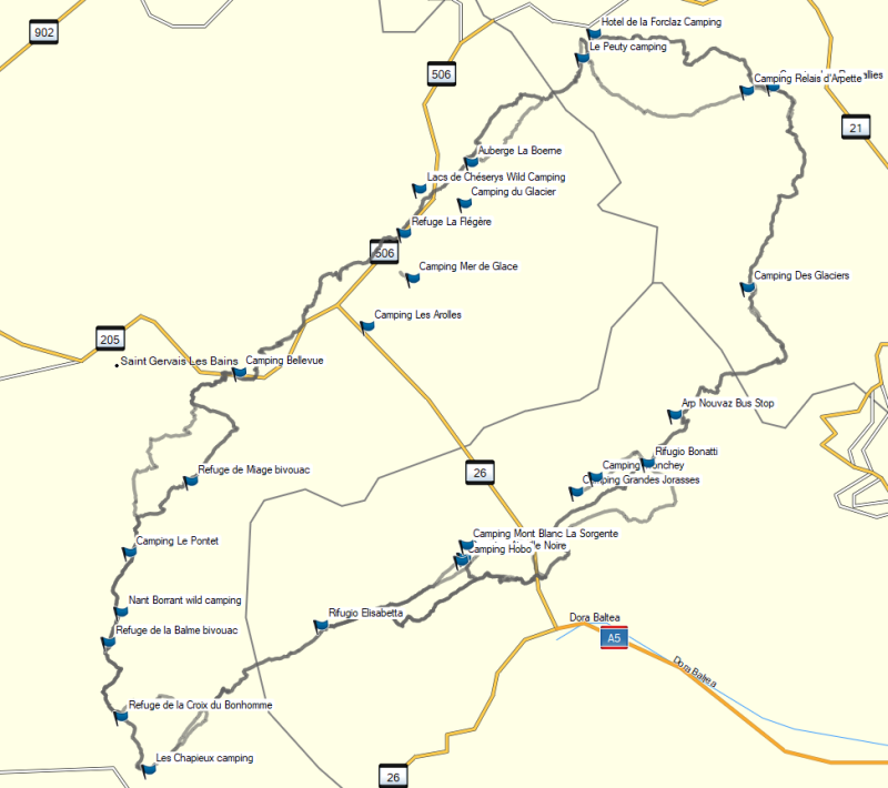
| 4 | Camping Aiguille Noire | Sleep | https://www.aiguillenoire.com/en/home-2/ |
| 4 | Camping Hobo | Sleep | http://www.campinghobo.com/en/ |
| 4 | Camping Mont Blanc La Sorgente | Sleep | https://www.campinglasorgente.net/en/ |
| 4 | Refuge Elisabetta | Sleep | https://www.rifugioelisabetta.com/index.html |
| Distance (km) | Elevation Gain (m) | Elevation Loss (m) | Shortcut | Notice |
|---|---|---|---|---|
| 8 | 705 | 383 | "Navette bus from Las Chapieux to Les Mottets (save 2 hours road walk). Les Chapieux to Refuge des Mottets Navette: This shuttle allows you to avoid about 2 hours of road walking at the beginning of Stage 3. It only costs a few euros to ride, and you can pick it up at the tourist information office in Les Chapieux. Upon reaching La Visaille, you can catch a local bus to Camping Aiguille Noire" | Make sure to buy your tickets in advance (do so the previous day, at the tourist office), as the shuttle fills up quickly in the mornings! |
https://www.rifugioelisabetta.com/index.html (參考資料)
- 兩人房宿舍
- 付費共⽤衛浴,無吹風機
- 插座:房間內、公共區域
- 餐廳可點飲料、中午時段提供餐點
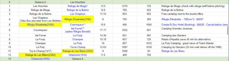
TMB Stage 3 Les Chapieux Col de la Seigne Elisabetta
- 從Les Chapieux出發,可以選擇先搭公車到Refuge des Mottets再健行,可以省下約2⼩時的公路路程
- 沿途無⽔源飲食補給
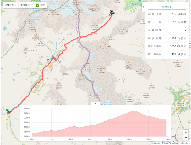
- 公⾥數:8 km
- 海拔升降:上升705m / 下降383m
- 最高點:Col de la Seigne (2516m),法義邊界 (隘口的展望很好)
- 預計時間:3.5 hr